Slide Mountain Trail
| Overall | ★★★☆☆ |
| Difficulty | ★★★☆☆ |
| Kid friendly | ★★★☆☆ |
| Parking | ☆☆☆☆☆ |
| A variety of hiking trails | ★★☆☆☆ |
I will introduce recommended spots for hiking with children in the United States. Today, I will introduce you to the Slide Mountain Trail.
Slide Mountain is the highest point in the Catskills. There are trail markers on the trail, so you hardly get lost. with little to no service in the area, however, I recommend downloading an offline map if you need it. Parking lot is spacious and free. There is no bathroom, so you should stop by a supermarket or gas station on the way.
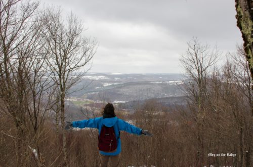
We hiked in winter, so the condition should be different from the warmer season. The trail leads you up the whole way. It seems like the trail is usually filled with stairs and has an elevation gain of over 400 feet until the first section, where we didn’t see any stairs because of snow. It was gentle for us. You’ll go left onto the Wittenburg, Cornell and Slide Trail at this section, which will be a game changer because it brings approximately 1,100 feet of elevation gain over the next 1.2 miles. Please take your time to catch your breath and take a water break. Depending on the trail’s condition, you might need to wear snowshoes. (We wore only spikes though) Needless to say, it was beautiful as trees were covered with snow and ice. I felt like I was hiking through tree caves. I guess you can have a nice tree shade during summer.
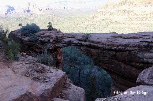
I have to give you an important notice about the summit. There are no views at the summit of Slide Mountain! The summit is completely below the tree line. If you want to see a good view, it is actually about 0.2 miles prior to the summit. We couldn’t take a picture at the view point nor the summit because it was below -10c/ -14F and my hands were frozen.
We had packed snow all the way, so we literally slid down when we went down. It didn’t take 1 hour to get back to the parking lot. I might have needed the poles though.
The Catskill Mountains are home to dozens of mountains, but only 35 are over 3,500 feet tall. Slide Mountain stands at 4,185 feet tall and offers stunning views of the layers and layers of mountains below. It’s worth a shot.
If you like this article, please click here! Thank you for your support.
Address: 2099 Oliverea Rd, Big Indian, NY 12410
Park Trail Map – Here
free parking
Elevation: 1,781ft
Length : 5.3-mile out-and-back trail
アメリカで、子連れハイキングのおすすめスポットを紹介していきます。今回はニューヨーク州にある、スライド山のトレイルを紹介します。
キャッツキル山地の最高峰といわれているスライド山。道中、携帯の電波が入らないところがあるほど山奥なので、トレイルマップが必要な人はあらかじめダウンロードしておくとよいでしょう。駐車場は無料、そして広いです。トイレはないので、近くのスーパーやガソリンスタンドですませておきましょう。
見ての通り、冬の雪深い時にハイキングをしたので、夏のコンディションは全く違うものになると思います。最初から登りがつづきますが、スタート地点から最初の分岐点まではなだらかです。他の人のレビューによると、普段は分岐点まで階段が続いているようです。分岐点で、Wittenburg, Cornell and Slide Trailという方向、左手側に進みます。その後、急な坂道が続くので、ゆっくり、水分をしっかりとりながら登るといいでしょう。私たちはスパイクのみでしたが、スノーシューズがあると便利だと思います。いうまでもなく、木に積もった雪が氷になり、一面銀色世界なのは、きれいの一言に尽きました。最後に大切なことは、スライド山の頂上からは、景色を見ることができません(笑)頂上から約0.2マイルほど下ったところに、ビューポイントがあるので、そこでキャッツキル山地の眺めを楽しむことを勧めます。私たちはー10度を下回る強風の中でのハイキングだったため、写真を撮れなかったのが残念でした。下りは、ひたすらくだっていくだけなので、雪道のくだりにかかった時間は、40~50分ほどでした。ポールがあると、足の負担が減ると思います。
キャッツキル山地にはたくさんの山がありますが、標高3,500フィート(約1,067m)を超える山は35か所だけです。スライド山は、標高4,185フィート(約1,276m)なので、登る価値は十分あると思います。
気に入ったら、クリックをお願いします。